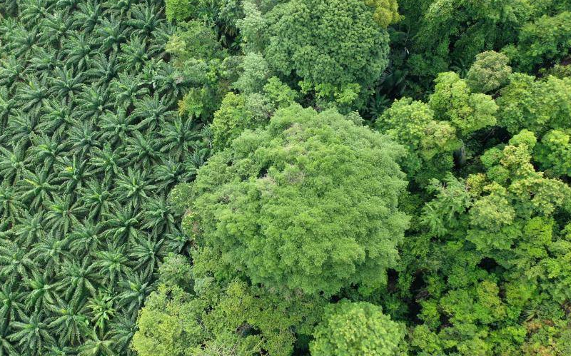
Barry Callebaut has welcomed the results of a groundbreaking large-scale High Carbon Stock map, using artificial intelligence (AI) offering precise coverage of areas at risk of deforestation in cocoa-growing territories of Malaysia, Indonesia and Philippines, reports Neill Barston.
The new sustainability project is a venture between EcoVision Lab, part of the Photogrammetry and Remote Sensing group at ETH Zurich, who have the capability to develop highly automated artificial intelligence solutions applied to ecological challenges.
Consequently, its team is reportedly using data from a NASA laser scanner attached to the International Space Station and imagery from the European Space Agency (ESA), which allows large areas to be mapped.
As Barry Callebaut noted, identifying and measuring specific areas of forest that are at risk in a high level of detail has been historically especially challenging and costly, which this latest scheme has set out to address. But with AI solutions already being put into place to examine predictions for droughts, cloud cover, and greenhouse gas emissions, its use for commodities such as cocoa are now possible.
The new venture, which is a publicly available High Carbon Stock (HCS) map that identifies forests with high conservation value and areas where deforestation would cause the highest carbon emissions. Its development supports the current approach of data taken from the field, which until now is the widely used approach to measure the link between commodity cultivation and deforestation, the so-called High Carbon Stock Approach (HCSA).
“This new method combining deep learning and publicly available satellite imagery is a true breakthrough because it provides a highly automated, transparent, objective tool that generates indicative HCS maps at global scale with unprecedented accuracy,” Prof. Dr. Jan Dirk Wegner, Head of EcoVision Lab, ETH Zurich & University of Zurich.
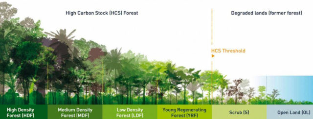
HCSA is a widely recognised methodology that is increasingly being used by certification standards, such as the Roundtable on Sustainable Palm Oil (RSPO), and by companies that are committed to breaking the link between deforestation and land development in either their operations or supply chain. The reliance on ground and aerial imagery for HCSA is challenging, because manually measuring landscapes and evaluating vegetation classes is labor-intensive and difficult to roll out at scale, whilst using planes equipped with specialised laser scanners is an expensive option.
As Barry Callebaut notes, implementing artificial intelligence solutions, begins with data quality. Deep learning is a research field with a very fast pace. New algorithms are improving quickly and are demonstrating the potential to revolutionise forest monitoring and carbon stock estimation based on satellite images. However, when relying on supervised learning, that is, learning from large reference datasets, the amount and quality of data is the key to success.
Welcoming the development of the scheme, Massimo Selmo, Head of Global Sourcing, Barry Callebaut, said: “Over the past four years, the ETH team has focussed on utilising the new satellite imagery and calibrating regional carbon biomass data. As a result, we have developed a tool that is highly automated, objective and can be used to up-scale indicative HCS mapping to entire world regions.
“Being carbon and forest positive is one of the key commitments of Forever Chocolate. These maps are the result of a 4-year collaboration with one of the leading research institutions combining artificial intelligence with remote sensing for ecosystem protection. By partnering together we have created an innovative and scalable solution that can be accessed by all.”
By Jan Dirk Wegner, Massimo Selmo